


Anchorage International Airport Climate Highlights for March 2024
Published 2024-04-04
Test of the Tsunami Warning System in Alaska this morning complete
Published 2024-03-27
Anchorage International Airport Climate Highlights for February 2024
Published 2024-03-02
Anchorage International Airport Climate Highlights for January 2024
Published 2024-02-09
Anchorage International Airport Annual Climate Highlights for 2023
Published 2024-01-16
Anchorage International Airport Climate Highlights for December 2023
Published 2024-01-15
WFO Anchorage Internet Outage
Published 2023-12-24
Upper Cook Inlet Community Meetings to Address Updated Tsunami Hazard Report - Oct 17th through Oct 20th 2023
Published 2023-10-17
September 2023 Monthly Climate Stats - Anchorage Ted Stevens Int'l Airport
Published 2023-10-09
August 2023 Monthly Climate Stats - Anchorage Ted Stevens Int'l Airport
Published 2023-09-03
🚨 Nationwide test of FEMA emergency alerts scheduled for Wednesday October 4, 2023
Published 2023-09-02
â— Anchorage Federal Building Power Outage Will Affect Some NWS Operational Data from August 25 to August 28, 2023
Published 2023-08-25
Soliciting Comments on Transition to Plain Language Headlines within NWS Alerting System through September 17, 2023
Published 2023-08-25
July 2023 Monthly Climate Stats - Anchorage Ted Stevens Int'l Airport
Published 2023-08-17
June 2023 Monthly Climate Stats - Anchorage Ted Stevens Int'l Airport
Published 2023-07-02
WFO Anchorage Zone Realignment StoryMap - effective September 19, 2023
Published 2023-06-30
Changes to Public Forecast Zones for WFO Anchorage, AK, Effective September 19, 2023
Published 2023-06-30
May 2023 Monthly Climate Stats - Anchorage Ted Stevens Int'l Airport
Published 2023-06-02
NWS Alaska Weather TV program is soliciting comments through July 30, 2023 on changes in how the public views the program. Click here for details and how to provide feedback.
Published 2023-05-16
📣 Upcoming Spotter Training! 👀
Published 2023-05-12
April 2023 Monthly Climate Stats - Anchorage Ted Stevens Int'l Airport
Published 2023-05-04
💧 Flood Safety Awareness Week is April 16-22, 2023
Published 2023-04-14
NO ASHFALL IS EXPECTED FOR ALASKA COMMUNITIES FROM THE RECENT ERUPTION OF SHEVELUCH VOLCANO...
Published 2023-04-13
2023 Summer Student Internship Opportunity with NWS Alaska
Published 2023-04-10
March 2023 Monthly Climate Stats - Anchorage Ted Stevens Int'l Airport
Published 2023-04-07
Test of the Tsunami Warning System is Complete
Published 2023-03-29
We've made big changes and our marine forecasts are much more detailed. Click here for more information.
Published 2023-03-12
February 2023 Monthly Climate Stats - Anchorage Ted Stevens Int'l Airport
Published 2023-03-02
Removal of Watch Warning Advisory (WWA) Section at the Base of the WFO Anchorage Forecast Discussions
Published 2023-02-28
Proposed changes to Flood Outlook Products
Published 2023-02-24
PNS for proposed changes to Flood Outlook Products
Discontinuation of the Recreational River Forecast
Published 2023-02-24
PNS for discontinuation of the Recreational River Forecast
Extreme Vessel Icing possible in Kamishak Bay and Shelikof Strait Sunday afternoon through early Monday morning
Published 2023-02-11
January 2023 Monthly Climate Stats - Anchorage Ted Stevens Int'l Airport
Published 2023-02-03
The Chugach National Forest Avalanche Information Center has issued an Avalanche Bulletin for Turnagain Pass and the Kenai and western Chugach Mountains
Published 2023-01-21
2022 Annual Climate Stats - Anchorage Ted Stevens Int'l Airport
Published 2023-01-11
Weather Spotter Training in Seward: Monday January 9 @ 5:30PM
Published 2023-01-05
December 2022 Climate Highlights: Anchorage - Ted Stevens Int'l Airport
Published 2023-01-03
...POTENTIAL FOR STRONG LOW TO BRING WINDS AND WINTRY MIX TO SOUTHCENTRAL THIS WEEKEND...
Published 2022-12-29
December 14-15, 2022 Storm Total Snow Reports
Published 2022-12-16
December 11-12, 2022 Storm Total Snow Reports
Published 2022-12-13
December 5-7, 2022 Storm Total Snow Reports
Published 2022-12-08
Radar Outage through Wednesday
Published 2022-12-05
November 2022 Anchorage Climate Summary
Published 2022-12-05
✨NEW✨ "nearshore" marine zones out to 15nm will be implemented statewide in March 2023
Published 2022-11-15
FREEZE UP ICE JAMS ONGOING IN ANCHORAGE BOWL AND MAT-SU VALLEY...
Published 2022-11-10
📣 Virtual Weather Spotter Training: November 17th 💻
Published 2022-11-09
AREAS OF MODERATE TO HEAVY SNOW ALONG THE STERLING HIGHWAY FROM NINILCHIK TO NIKISKI THROUGH WEDNESDAY AFTERNOON
Published 2022-11-02
Transition of the South Central Alaska Mountain Recreational Forecast (REC) to the Avalanche Weather Guidance (AVG)
Published 2022-10-11
Hurricane Force Low in the Bering will bring High Winds and Coastal Storm Surge
Published 2022-09-16
National Cooperative Observer Newsletter: Spring/Summer 2022
Published 2022-09-02
Upcoming Changes to Avalanche Products
Published 2022-08-26
Alaska Weather Information Line Outage
Published 2022-08-22
Climate Data Experiencing Technical Difficulties
Published 2022-08-21
NOAA Weather Radio is Experiencing Technical Difficulties
Published 2022-08-18
Anchorage International Airport Climate Highlights July 2022
Published 2022-08-04
Anchorage International Airport Climate Highlights for June 2022
Published 2022-07-01
The Anchorage International Airport Climate Highlights for June 2022.
Changes to the Alaska Weather Information Line Phone Number: Effective on or after August 5, 2022
Published 2022-06-06
Marine Weather Statement: Rapidly Deteriorating Conditions Expected for Cook Inlet
Published 2022-05-08
Point and Click Forecast Outage -- Please use this alternative for your forecast
Published 2022-05-06
âš STRONG SOUTHEASTERLY WINDS SUNDAY EVENING THROUGH MONDAY MORNING FOR THE ALASKA PENINSULA...
Published 2022-04-17
âš STRONG SOUTHEASTERLY WINDS EARLY SUNDAY AFTERNOON THROUGH SUNDAY EVENING FOR THE EASTERN ALEUTIANS...
Published 2022-04-17
Anchorage International Airport Climate Highlights for February 2022
Published 2022-03-04
Avalanche Warning in effect through 6 PM this evening for the Western Chugach and Kenai Mountains
Published 2022-02-25
THE CHUGACH NATIONAL FOREST AVALANCHE CENTER HAS ISSUED AN AVALANCHE WARNING for the following areas: Girdwood, Portage, Moose Pass, Turnagain Pass, Summit Lake, Lost Lake, and Seward. In effect through Fri 6:00 PM AKST.
...THE HATCHER PASS AVALANCHE CENTER HAS ISSUED AN AVALANCHE WARNING...
Published 2022-02-22
Recap of the February 21-22, 2022 Southcentral Winter Storm
Published 2022-02-22
NWS Alaska Region Zone Changes Now In Effect! Click for more info.
Published 2022-02-17
Comments Welcome on the Experimental Avalanche Weather Web Page through April 30, 2022
Published 2022-01-28
LIGHT RAIN MONDAY EVENING WILL CHANGE TO SNOW TUESDAY MORNING ACROSS SOUTHCENTRAL
Published 2022-01-25
AREAS OF LIGHT RAIN/FREEZING RAIN ALONG THE SEWARD HIGHWAY THROUGH EARLY TUESDAY MORNING
Published 2022-01-11
Hurricane Force Winds and Heavy Freezing Spray along the south side of the Alaska Peninsula overnight tonight through Saturday night...
Published 2021-12-31
Ice Reports from across Southcentral: December 28th
Published 2021-12-29
Freezing Rain Reports 28DEC2021
HATCHER PASS SPECIAL AVALANCHE BULLETIN
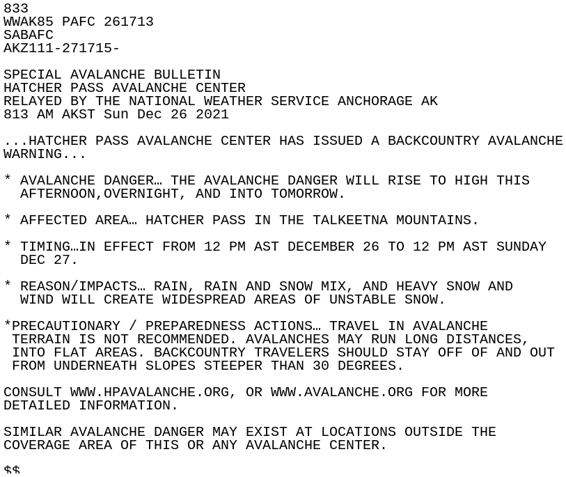
Published 2021-12-26
HATCHER PASS AVALANCHE CENTER HAS ISSUED A BACKCOUNTRY AVALANCHE WARNING UNTIL NOON TODAY, MONDAY DECEMBER 27.
Snowfall totals around Southcentral from the December 20th Storm
Published 2021-12-21
...HURRICANE FORCE WINDS AND HEAVY FREEZING SPRAY ALONG THE SOUTH SIDE OF THE ALASKA PENINSULA TONIGHT THROUGH SATURDAY NIGHT...
Published 2021-12-10
Light to Moderate Snow to Continue through the Evening in Southcentral
Published 2021-12-01
Early Kenai River freeze up is possible
Published 2021-11-22
Southcentral Preliminary Storm Total Snowfall
Published 2021-11-12
Snow Totals!
Published 2021-11-11
Widespread Snowfall Likely Across Southcentral Wednesday Afternoon through Thursday Afternoon
Published 2021-11-10
Halloween Weekend Rainfall Totals
Published 2021-11-04
PRELIMINARY RAINFALL AMOUNTS FROM HALLOWEEN WEEKEND STORM
Published 2021-11-02
NOAA Weather Radio Outage for Saint Paul until Further Notice
Published 2021-10-26
The NOAA Weather Radio for Saint Paul Island is down until further notice. We apologize for this inconvenience and please reference the link URL to see further info on where to access weather info.
Strong Winds for the Pribilof Islands
Published 2021-10-07
Winter Weather Advisory in effect for the Northern Susitna Valley from 1am Wednesday through 1am Thursday
Published 2021-10-04
Resuspended ash from Novarupta over Kodiak Island through Tuesday
Published 2021-09-21
Resuspended Ash from Novarupta Likely to Impact Southern Kodiak Island Monday Night through Tuesday
Published 2021-09-19
Strong Winds Over Whittier and Seward Monday Night Through Wednesday
Published 2021-09-19
An early season storm to bring possible snow and blowing snow to Thompson Pass
Published 2021-09-19
First accumulating snow of the season possible for Copper River Basin
Published 2021-09-19
First Widespread Frost or Freeze Likely Early Sunday Morning for parts of Southcentral
Published 2021-09-18
Kodiak NOAA Weather Radio Transmitter Temporarily Out of Service
Published 2021-09-01
Gulf of Alaska Data Buoy Outage Begins May 30th, 2021
Published 2021-05-28
Bethel NOAA Weather Radio Outage Today
Published 2021-05-13
Whittier NOAA Weather Radio Intermittent Outage
Published 2021-05-05
Special Avalanche Bulletin
Published 2021-04-16
The Chugach National Forecast Avalanche Information Center has issued an Avalanche Warning for the Western Chugach and Kenai Mountains
Published 2021-04-14
Snow Totals from Thursday March 25th, 2021
Published 2021-03-26
Two River Stage Changes April 18 2021
Published 2021-03-19
Anchorage Snow Totals
Published 2021-03-11
Planned Major Change to NWS' Hazard Messaging Headlines No Earlier than 2024
Published 2021-03-04
Having problems with the new NWS radar webpage? Try these tips to help you find the information you need
Published 2021-02-10
Storm Total Snowfall Reports for January 23-24, 2021- Local Storm Reports Page
Published 2021-01-24
BACKCOUNTRY AVALANCHE WARNING in effect until 6am Wednesday for the Western Chugach and Kenai Mountains
Published 2021-01-12
We are currently experiencing a technical issue which is preventing the latest Alaska Weather broadcast from displaying on the webpage. The latest episode of the show can be found here
Published 2021-01-12
BACKCOUNTRY AVALANCHE WARNING in effect until 6am Tuesday for the Western Chugach and Kenai Mountains
Published 2021-01-11
Delay in forecast products this evening
Published 2020-12-22
Snowy Wednesday Morning Commute
Published 2020-12-16
Missing observations expected at Augustine Island
Published 2020-12-15
Freezing Rain Threat Has Ended. Light Snow Expected Tonight Into Tuesday for Anchorage, the Mat-Su, and Western Kenai Peninsula
Published 2020-12-07
Our NWS radar display will be changing nationally on or about December 16th. Here's a tutorial to help you navigate the upcoming changes.
Published 2020-12-05
BACKCOUNTRY AVALANCHE WARNING IN EFFECT UNTIL 600 AM WEDNESDAY FOR THE WESTERN CHUGACH AND KENAI MOUNTAINS
Published 2020-12-01
A Wet, Windy, and Warm Storm to Start the Week for Western Prince William Sound
Published 2020-11-30
Multiple Storms Set to Impact Holiday Travel
Published 2020-11-24
Snow Totals for Anchorage and the Matanuska Valley- November 22, 2020
Published 2020-11-22
Please provide your feedback to us on NWS Frost/Freeze Products!
Published 2020-11-18
Glacial Dammed Lake on Bear Glacier in Resurrection Bay has released
Published 2020-11-13
Freeze up Ice Jam on the Talkeetna River
Published 2020-11-12
Kenai Radar Outage During Major Upgrade
Published 2020-10-23
Attention: National Radar Outage
Published 2020-10-15
Intermittent Outages on NOAA Weather Radio on Thursday, October 8 from 9am to 3pm
Published 2020-10-06
Anchorage Intl Airport Climate Highlights for September 2020
Published 2020-10-05
Patchy Dense Fog Over Anchorage and the Matanuska Valley This Morning
Published 2020-09-25
Wind and Rain for Southcentral Wednesday through Friday
Published 2020-09-16
SOUTHCENTRAL ALASKA: Chilly early morning temperatures to start the Labor Day weekend
Published 2020-09-05
Power Outage could impact products Sat 22 AUG
Published 2020-08-21
Tazlina Glacier Dammed Lake Release
Published 2020-08-19
Flood Stage Changes for the Eagle River at Glenn Highway
Published 2020-08-05
HIGH WATER LEVELS EXPECTED ON RIVERS AND STREAMS IN THE SUSITNA VALLEY AND SOUTHERN ALASKA RANGE TONIGHT THROUGH MONDAY
Published 2020-08-02
SIGNIFICANT RAIN WILL DEVELOP OVER THE SUSITNA VALLEY THIS EVENING AND CONTINUE THROUGH AT LEAST MONDAY MORNING, WITH HEAVIEST RAIN OCCURRING TONIGHT INTO SUNDAY MORNING. EXPECT STORM TOTAL RAINFALL AMOUNTS OF 1 TO 3 INCHES, WITH LOCALLY HIGHER AMOUNTS ALONG THE ALASKA RANGE.
HIGH WATER ON THE MATANUSKA RIVER
Published 2020-07-20
Flood stage changes for Montana Creek and the Talkeetna River in the Susitna Valley.
Published 2020-07-08
NWS Alaska Region Internet Issues!
Published 2020-07-07
National Weather Service Alaska is experiencing a data outage for some forecast products. Watches, Warnings and Advisories are still current, but point forecasts may not be available or may be out of date. Hourly forecast information is also currently unavailable.
Network Maintenance Rescheduled to June 30th, which will affect National Weather Service Alaska services
Published 2020-06-27
PLANNED POWER OUTAGE JUNE 20TH WILL AFFECT NATIONAL WEATHER SERVICE ALASKA DATA DISTRIBUTION
Published 2020-06-16
Water Level Rises Expected From The Release of Valdez Glacier Dam Lake
Published 2020-06-12
New Barry Arm Landslide Tsunami Risk Webpage
Published 2020-05-28
Landslide-generated tsunamis are a continuous concern in Prince William Sound. Learn more about what NWS Anchorage and National Tsunami Warning Center are doing to keep you safe here!
Special Avalanche Bulletin for Hatcher Pass
Published 2020-03-13
River Gage Datum Updates
Published 2020-03-12
NWS river gage elevation metadata has been updated for some of the gages in Southcentral Alaska. The USGS has surveyed a number of area river gages from NGVD29 to the higher resolution NAVD88 vertical datum. The NWS has updated our records to match these changes.
Sunday - Monday Snow Totals Across Southcentral
Published 2020-03-03
Heads Up For Monday Morning Commuters in Anchorage and the Matanuska Valley
Published 2020-03-01
Snowfall Across the Anchorage Bowl Through Sunday Evening... Up to 5 inches
Published 2020-02-29
Special Avalanche Bulletin Chugach National Forest
Published 2020-02-23
BACKCOUNTRY AVALANCHE WARNING for Hatcher Pass in effect through Noon Wednesday 2/19
Published 2020-02-18
BACKCOUNTRY AVALANCHE WARNING for the Kenai and Western Chugach Mountains in effect through 6am Wed 2/19
Published 2020-02-18
Anchorage & Matanuska Valley: Strong winds with warm temperatures Monday night will give way to snow on Tuesday
Published 2020-02-17
WATER FLOWING OVER THE TOP OF MATANUSKA RIVER ICE AFFECTING LOW LYING AREAS NORTH OF MAUD ROAD IN PALMER...
Published 2020-01-18
Baseline/Datum Value Change Notice at Tununak along the Kuskokwim River Delta
Published 2020-01-13
30 Day Change Notice, Please leave available at the top of the website, weather permitting, through February 12.
Ice Jam Flooding continues on Willow Creek upstream of the Deneki Road bridge
Published 2020-01-03
Here are snow reports from the New Year's snowstorm
Published 2020-01-01
Heavy snow expected this afternoon and tonight across the Cook Inlet area.
Published 2019-12-31
Winter Weather may impact Holiday Travel
Published 2019-11-26
Strong Storm to Impact Southwest Alaska Monday and Tuesday
Published 2019-11-24
Southcentral Snow Amounts
Published 2019-11-17
A WINTER WEATHER ADVISORY IN EFFECT UNTIL 6 AM FRIDAY FOR THE LOWER KUSKOKWIM VALLEY
Published 2019-10-31
Whittier Weather Station Inoperable Through Early November
Published 2019-10-23
Patchy Freezing Rain Possible in the Matanuska Valley Early Monday Morning
Published 2019-10-21
A WINTRY MIX OF PRECIPITATION WITH TEMPERATURES NEAR FREEZING WILL CONTINUE THROUGH THE OVERNIGHT HOURS IN THE ANCHORAGE BOWL
Published 2019-10-17
A WINTRY MIX OF PRECIPITATION WITH TEMPERATURES NEAR FREEZING WILL CONTINUE THROUGH THE OVERNIGHT HOURS IN THE ANCHORAGE BOWL
SNOW WILL OCCUR ALONG THE RICHARDSON HIGHWAY FROM PAXSON NORTH TODAY AND SPREAD ACROSS THE COPPER RIVER BASIN TONIGHT
Published 2019-10-10
WINTER DRIVING CONDITIONS THROUGH WEDNESDAY ALONG THE PARKS HIGHWAY NORTH OF TALKEETNA AND RICHARDSON HIGHWAY FROM PAXSON NORTH
Published 2019-10-09
A WEATHER SYSTEM MOVING ACROSS WESTERN ALASKA IS SPREADING LIGHT SNOW ALONG THE PARKS HIGHWAY NORTH OF TALKEETNA AND OVER THE RICHARDSON HIGHWAY FROM PAXSON NORTH.
Public Information Statement: Higher Than Normal Water Along Eklutna River
Published 2019-09-21
...HIGHER THAN NORMAL WATER ALONG THE EKLUTNA RIVER FROM EKLUTNA LAKE DOWNSTREAM TO TIDEWATER... EKLUTNA LAKE IS CURRENTLY AT A LEVEL WHERE WATER FLOWS OVER THE SPILLWAY INTO THE UPPER EKLUTNA RIVER. THIS IS A NORMAL CONDITION OCCURRING ABOUT EVERY SEVEN YEARS. FLOWS ALONG THE LOWER EKLUTNA RIVER ARE EXPECTED TO BE BETWEEN ONE TO TWO FEET DEEPER THAN NORMAL FOR THIS TIME OF YEAR.
Record Daily Rainfall at Anchorage
Published 2019-09-19
First daily record rainfall observed since May
A Glacier Dammed Lake on Bear Glacier in Resurrection Bay is Releasing
Published 2019-09-06
A Glacier Dammed Lake on Bear Glacier in Resurrection Bay is Releasing
Published 2019-09-05
Upcoming Weather Spotter Training: September 18th in Kodiak
Published 2019-09-02
ELEVATED WATER LEVELS AND MINOR COASTAL EROSION POSSIBLE THROUGH TONIGHT FOR KUSKOKWIM BAY TO HOOPER BAY
Published 2019-09-01
Special Weather Statement: Areas of smoke will persist across the Kenai Peninsula, Anchorage Bowl, and Mat-Su Valleys
Published 2019-08-19
Record Highs Set Across Southcentral on August 7th
Published 2019-08-08
Elevated Water Levels on Rivers and Streams
Published 2019-07-07
Elevated water levels on rivers and streams
All-time high temperature records were set throughout southern Alaska. Check them out!
Published 2019-07-05
A Dense Smoke Advisory has been issued for the interior Kenai Peninsula as well as from the Sterling Hwy Junction south to Seward
Published 2019-07-01
Smoke expected to increase in Anchorage and Matanuska Valley over the weekend
Published 2019-06-29
Smoky conditions are expected to continue around Southcentral through the weekend. For more information on air quality, visit http://dec.alaska.gov/Applications/Air/airtoolsweb/Aq/
Dense smoke along the Sterling and Seward Highways
Published 2019-06-26
A dense smoke advisory is in effect for the Kenai Peninsula and could last into the weekend due to the Swan Lake Fire. Visibility can quickly drop to nearly zero in a very short time.
STRONG THUNDERSTORM OVER THE GLENN HIGHWAY NEAR CHICKALOON
Published 2019-06-24
EXPECT HIGH WATER AND POTENTIAL BANK EROSION ALONG STREAMS OF THE MATANUSKA VALLEY AND HIGH WATER ALONG STREAMS OF THE SUSITNA VALLEY
Published 2019-06-22
Anchorage International Climate Highlights for May 2019
Published 2019-06-21
Report any hail, damaging winds, heavy rain or flooding by clicking HERE!
Published 2019-06-04
Another round of thunderstorms are expected throughout Southcentral. Learn more here!
Published 2019-06-04
High Wind Warning In Effect For the Hillside and Turnagain Arm for Friday Afternoon & Evening- May 10
Published 2019-05-09
...STRONG WINDS EXPECTED ACROSS SOUTHCENTRAL ON FRIDAY...
Published 2019-05-09
Another Round of Winter Weather across much of Southcentral
Published 2019-04-22
Another round of snow is expected for Southcentral Thursday night through Friday. Learn more here.
Published 2019-04-18
Did you get any snow on the 17th? Check out the storm reports for Anchorage up to the Matanuska Valley
Published 2019-04-17
Forecast Information Delay
Published 2019-04-12
Weather information not updating for some in Southwest Alaska
Winter may be coming back to the Anchorage area Friday morning! Learn more about the expected precipitation here.
Published 2019-04-12
Anchorage International Airport Climate Highlights for March 2019
Published 2019-04-01
...KENAI PENINSULA BOROUGH TO TEST TSUNAMI SIRENS ON WEDNESDAY MARCH 27...
Published 2019-03-26
A number of C-MAN stations are expected to be down for necessary maintenance from April 6th to November of 2019. Click in for more information.
Published 2019-03-22
Widespread snow expected from King Salmon north to Sleetmute and from Koliganek east to Iliamna. Click here to learn more.
Published 2019-03-17
Heavy Snow for Eastern Kenai Peninsula Wednesday through Friday
Published 2019-03-12
Heavy Snow for Eastern Kenai Peninsula Wednesday through Friday
HIGH WIND WARNING remains in effect for the Hillside and Turnagain Arm until 6am Sunday
Published 2019-03-09
Icy Conditions Across Much of Southcentral Alaska Through Tuesday Morning
Published 2019-02-19
Hatcher Pass Avalanche Danger Through 6pm Tuesday
Published 2019-02-18
Blizzard conditions are possible along the Kuskokwim Delta coast Friday.
Published 2019-02-14
A coastal storm is headed towards the Kuskokwim Delta coast. Elevated water levels and onshore winds expected.
Published 2019-02-11
Anchorage International Airport Climate Highlights for January 2019
Published 2019-02-09
Wintry Mix likely Monday afternoon through Tuesday morning in the Anchorage Area...
Published 2019-01-27
Glacier Dammed Release of Hidden Lake
Published 2019-01-23
Series of Storms to Impact Southcentral through the Weekend
Published 2019-01-23
Pockets of Freezing Rain this Evening for the Anchorage Bowl and Kenai Peninsula
Published 2019-01-16
Minor Flooding possible on the Anchor River
Published 2019-01-01
Backcountry Avalanche Warning
Published 2018-12-20
Winter Storm Warning in effect until 12PM Thursday AKST North of Moose Pass including Whittier, Portage, Girdwood
Published 2018-12-20
Special Weather Statement: Freezing Drizzle across Anchorage during Monday Morning Commute
Published 2018-12-17
Snowfall Totals for Anchorage for December 14th
Published 2018-12-15
SNOW FELL ACROSS THE ANCHORAGE BOWL FRIDAY AFTERNOON THROUGH THE EARLY MORNING HOURS ON SATURDAY. HERE IS A SUMMARY OF THE SNOWFALL REPORTS THAT WERE SUBMITTED FROM AROUND SOUTHCENTRAL:
Click here to see the latest snowfall reports for the greater Anchorage Area
Published 2018-12-13
Southcentral Snow Reports: 24 hour totals from Dec 8 2018 event
Published 2018-12-09
Volcanic Ashfall Advisory in effect for Perryville from 6PM Wednesday Nov 21 through 6AM Thursday Nov 22
Published 2018-11-21
Trace or Dusting of Volcanic Ash expected near Castle Cape to Cape Sarichef, and Sitkinak to Castle Cape.
Published 2018-11-21
Blizzard Warning and Winter Weather Advisories have been issued throughout Southcentral
Published 2018-11-10
First Accumulating Snow of the Season in Anchorage and the Matanuska Valley on Monday...
Published 2018-10-28
Special Weather Statement for Western Aleutians: Minor Eruption of Semisopochnoi
Published 2018-10-26
Recent heavy rain has brought the Kenai River near Cooper Landing to bankfull levels.
Published 2018-10-24
Strong winds and heavy rain is expected along the north Gulf Coast and Cook Inlet for the makings of a wet weekend.
Published 2018-10-19
Strong winds and heavy rain expected along the North Gulf Coast and Southern Cook Inlet through Sunday
Published 2018-10-17
Heavy rain and strong winds for the Prince William Sound region through tonight
Published 2018-10-15
Flood Advisory for the Resurrection River near Seward
Published 2018-10-12
NOAA weather radio will be temporarily down this afternoon
Published 2018-10-11
Check out the summary of this year's record breaking September
Published 2018-10-04
Click here for the event roundup for September 24th, 2018
Published 2018-09-25
Preliminary Storm Reports for Southcentral - Monday September 24
Published 2018-09-24
FIRST FALL STORM ARRIVES IN SOUTHCENTRAL MONDAY
Published 2018-09-23
Skilak Glacier Dammed Lake is Releasing
Published 2018-09-19
A warm September has led to 43 high temperature records throughout Southcentral and Southwest Alaska.
Published 2018-09-15
Sunday Morning Low Temperatures for Southcentral
Published 2018-09-07
Rapid water level rises expected on Beluga Lake and Beluga River through Sunday Evening
Published 2018-09-01
High water continues around the Susitna and Copper River Basin. Learn more by clicking here.
Published 2018-08-23
Due to technical difficulties, the NOAA Weather Radio weekly radio test was not transmitted. Click here for more details.
Published 2018-08-22
High Water Along the Maclaren and Gulkana Rivers
Published 2018-08-21
NOAA Weather Radio outage on Monday August 20
Published 2018-08-16
Update on NOAA Weather Radio outage
Published 2018-08-15
Rivers and Streams in the Susitna Valley expected to be near bankfull through wednesday evening.
Published 2018-08-14
High surf and coastal erosion possible along Kuskokwim Bay and Bristol Bay coasts Sunday night through Monday night
Published 2018-08-12
High Surf along Bristol Bay and Kuskokwim Bay Coasts Sunday Night Through Monday Night
Published 2018-08-11
Rain and Strong Winds in Store for Southcentral Alaska Sunday into Monday
Published 2018-08-11
RAPID AND SIGNIFICANT WATER LEVEL RISES IN BEAR GLACIER LAGOON THROUGH SATURDAY AFTERNOON
Published 2018-08-09
RISING WATER LEVELS ALONG THE DENALI HIGHWAY TODAY
Published 2018-08-06
Heavy rain in the Matanuska and Susitna Valleys Sunday morning through Monday morning brings potential for flooding...
Published 2018-08-04
You're invited! Join us at our free Open House event on Saturday, August 11th from 11AM - 4PM
Published 2018-07-25
A Red Flag Warning is in effect due to hot, dry and windy conditions in the Copper River Basin
Published 2018-07-22
Higher Water Levels Expected for the Kennicott, Chitina, and Copper Rivers
Published 2018-07-17
Anchorage International Airport Climate Highlights for June 2018
Published 2018-07-17
High Water Along the Eyak River near Cordova
Published 2018-07-11
RECENT HEAVY RAINS HAVE CAUSED THE EYAK RIVER NEAR CORDOVA TO REACH ACTION STAGE (23.5 FT) AT THE BRIDGE LATE THIS EVENING. WITH RAINFALL RATES SLOWING AS THE PRECIPITATION BECOMES MORE SHOWERY, THE RIVER IS EXPECTED TO CREST AT OR JUST BELOW MINOR FLOOD STAGE (24.5 FT) LATE TONIGHT OR EARLY WEDNESDAY MORNING.
Click here to learn more about the expected high water levels on the Kenai River
Published 2018-07-10
A Flood Warning has been issued for the Yentna and Skwentna Rivers. Learn more here.
Published 2018-07-10
Rising waters along the Yentna and Skwentna Rivers...
Published 2018-07-08
Heavy rain to bring rising water levels to the Kenai Peninsula beginning this weekend and a return to higher flows for the Matanuska River as well
Published 2018-06-15
Intermittent Outages for the King Salmon Radar
Published 2018-06-13
High waters expected across area rivers due to recent rains and snow melt
Published 2018-06-11
High waters expected across area rivers due to recent rains and snow melt.
Do you view our hazard products? We would appreciate your feedback! Click here to take this survey to help us make your hazard products better.
Published 2018-05-29
Day 2 of Safe Boating Week focuses on marine data and our need for your observations. Click here to learn more about #kbaywaves
Published 2018-05-20
Today is Day 1 of Safe Boating Week. Click here to learn more about life jacket safety.
Published 2018-05-19
There is NO Tsunami Threat
Published 2018-05-11
An Ice Jam Flood Advisory is in effect until 1115 AM AKDT Wednesday for Aniak
Published 2018-05-01
High Water Levels Expected along the West Coast from Kipnuk Northward
Published 2018-04-28
High winds may increase threat for coastal erosion for some in Southwest Alaska Sunday and Monday
Check out the 64 Wind Reports we received from the April 24th Windstorm all across Southcentral!
Published 2018-04-25
Continued Late Season Snow for the Northern Susitna Valley this week
Published 2018-04-25
Snow returning to the Southern Mainland through Thursday
Published 2018-04-03
Anchorage International Airport Climate Highlights for March 2018
Published 2018-04-03
HIGH WIND WARNING NOW IN EFFECT UNTIL 6 AM AKDT THURSDAY FOR VALDEZ AND THOMPSON PASS
Published 2018-03-21
* LOCATION...Valdez and Thompson Pass. * WIND...Northeast winds of 35 to 55 mph with gusts to 80 mph expected through Thompson Pass and out of northerly gaps and canyons in Valdez. A high wind warning means a hazardous high wind event is expected or occurring. People are urged to secure loose objects that could be blown around or damaged by the wind.
WINDY CONDITIONS EXPECTED WEDNESDAY AND WEDNESDAY NIGHT FOR THE MATANUSKA VALLEY
Published 2018-03-21
Northeasterly winds are expected to increase beginning Wednesday morning for the Matanuska Valley. Winds will be gusty and reach peak speed close to 65 mph Wednesday night. Driving may be difficult, especially across the usual windy areas such as Moose Flats. Secure loose objects and expect blowing debris.
Special Avalanche Bulletin for the Eastern Kenai Peninsula
Published 2018-03-16
Snow totals for the MAT-SU Valleys
Published 2018-03-16
A Special Avalanche Bulletin has been issued for Turnagain Pass and areas in and around Eastern Turnagain Arm. Click in for more details.
Published 2018-03-09
Check out the current local snowfall totals for the warnings that are currently out. These will be updated as they are reported.
Published 2018-03-08
High winds expected through Thompson Pass today.
Published 2018-02-28
Snow totals around Southcentral
Published 2018-02-27
A wintry mix of precipitation expected today
Published 2018-02-12
Precipitation returning to Southcentral for Sunday and Monday
Published 2018-02-10
NOAA Weather Radio Outage February 7th, 2018
Published 2018-02-06
Snow and Blowing Snow expected this afternoon north and west of Dillingham.
Published 2018-02-05
Water levels rising on the Kenai River as freeze-up continues
Published 2018-01-29
The recent cold snap has caused the Kenai River freeze-up process to kick into high gear. As ice fills the river, it can build up and start to restrict the flow in the river channel. This has caused water levels to rise considerably during the last week near Soldotna.
Windy conditions expected in the Matanuska Valley, Thompson pass and Valdez.
Published 2018-01-27
Moderate Snowfall Expected for the Cordova Area Overnight Tonight through Thursday Afternoon
Published 2018-01-25
Storm total accumulation of around 12 inches is expected, with locally higher amounts on the mountains. An east wind of 10 to 20 mph will develop, blowing the light, dry snow around and reducing visibilities to less than 1/2 mile at times.
Snow totals around Southcentral Alaska as of late this afternoon
Published 2018-01-24
Snow headed towards Southcentral Alaska Monday night through Tuesday.
Published 2018-01-21
Wind Chill Advisory in Effect Tonight For the Kuskokwim Delta
Published 2018-01-21
Kenai Radar Outage
Published 2018-01-17
Winter Weather Advisory south and east of Glennallen.
Published 2018-01-14
The Chugach National Forest Avalanch Center has issued a Backcountry Avalanche Warning for Turnagain Pass & the Kenai & Western Chugach Mountains in & around Eastern Turnagain Arm.
Published 2018-01-13
Anchorage December and Annual 2017 Climate Highlights
Published 2018-01-07
Storm Total Snowfall for January 3, 2018
Published 2018-01-04
Got snow? Tell us how much!
Published 2018-01-03
Census Area Name and FIPS code change
Published 2017-05-16
This SCN is for the change of the Wade Hampton Census Area to the Kusilvak Census Area and the FIPS code change for this area from 02270 to 02158.