 Email the author
Overview
On Monday, 8 April 2024 between 3:24 pm and 3:30 pm EDT a total solar eclipse graced the skies over northern New York and northern Vermont. While all of the continental United States experienced at least a partial solar eclipse, portions of our region were fortunate to be aligned within the path of totality (Fig. 1). Totality near the eclipse centerline in our region lasted roughly 3 minutes and 35 seconds as the moon's shadow raced northeastward at roughly 2,600 mph. The path of totality was roughly 120 miles wide.
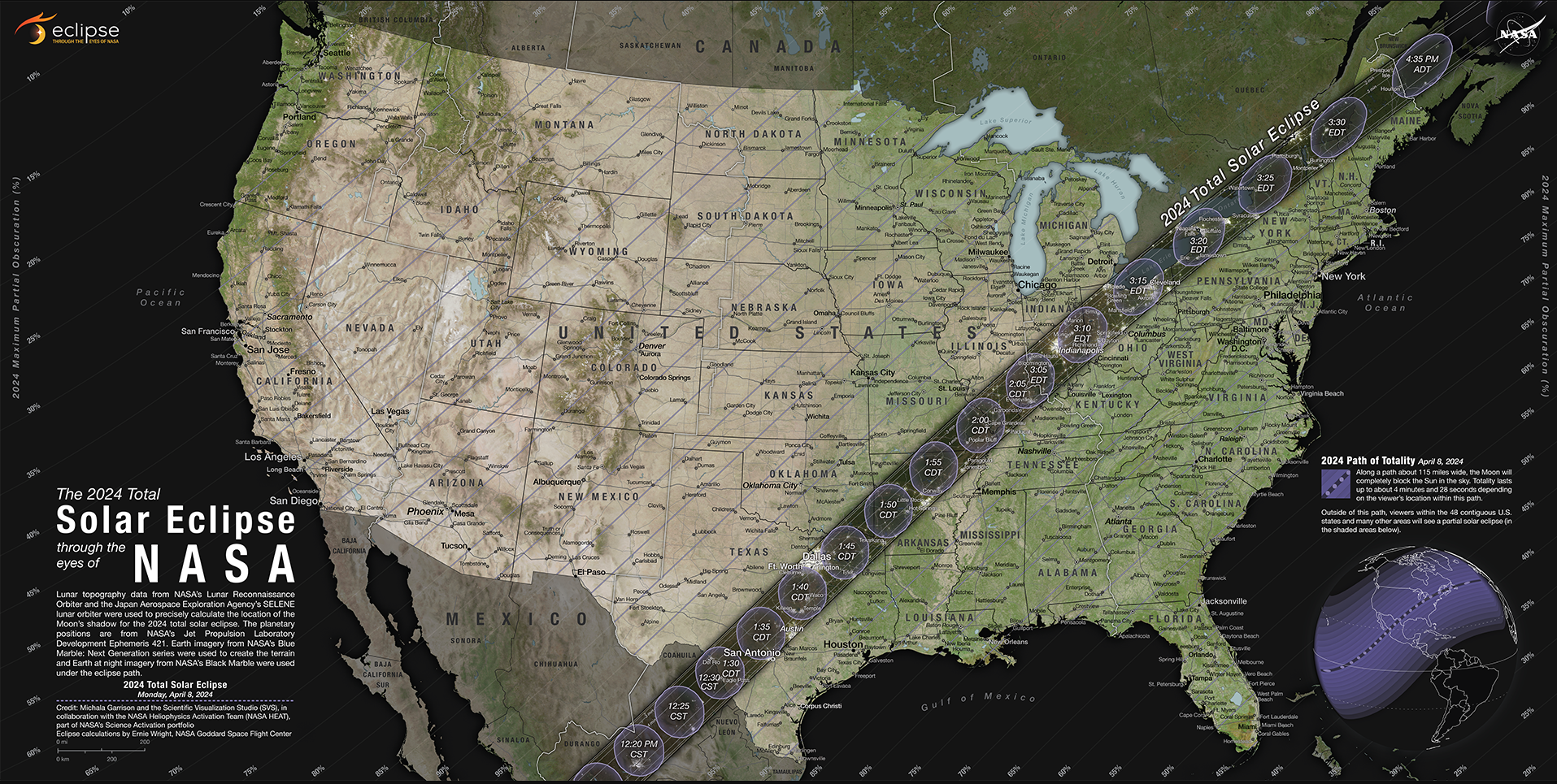
Figure 1. Map showing the path of the eclipse and location with respect to time (courtesy NASA).[click to enlarge]
A total solar eclipse happens when the Moon passes between the Sun and Earth, completely blocking the face of the Sun (Fig. 2). Total solar eclipses are rare. There are two main reasons for this. First, because the Moon's orbit is tilted by 5 degrees compared to the plane of Earth's orbit around the Sun, solar eclipses don't occur every ~28 days with the orbital period of the moon. From the perspective of the moon, its location is usually above or below the orbital plane of the Earth-Sun system, which results in the moon's shadow not often being cast across the Earth. Second, because the moon's orbit is elliptical, the relative size of the moon may not completely obscure the sun, even when alignment of the Sun, Earth, and moon is favorable. The moon is roughly 400 times smaller than our Sun, but also happens to be roughly 400 times closer to the Earth. If the moon is relatively close to the Earth in its elliptical orbit (i.e., closer to perigee) during a solar eclipse, the moon will completely mask the sun. If the moon is relatively far from the Earth during its elliptical orbit (i.e., closer to apogee) during a solar eclipse, an annular eclipse will result (Fig. 3).
Indeed, total solar eclipses are rare events, occurring on average in any particular location only once every 375 years. The total solar eclipse on April 8, 2024 was the first anywhere in Vermont since 1932. However, this is the first time Burlington has been in the path of totality since 1569. The next total solar eclipse anywhere in Vermont will take place just after sunrise on 1 May 2079. The next total solar eclipse in Burlington, Vermont occurs around noon EDT on 2 August 2399.
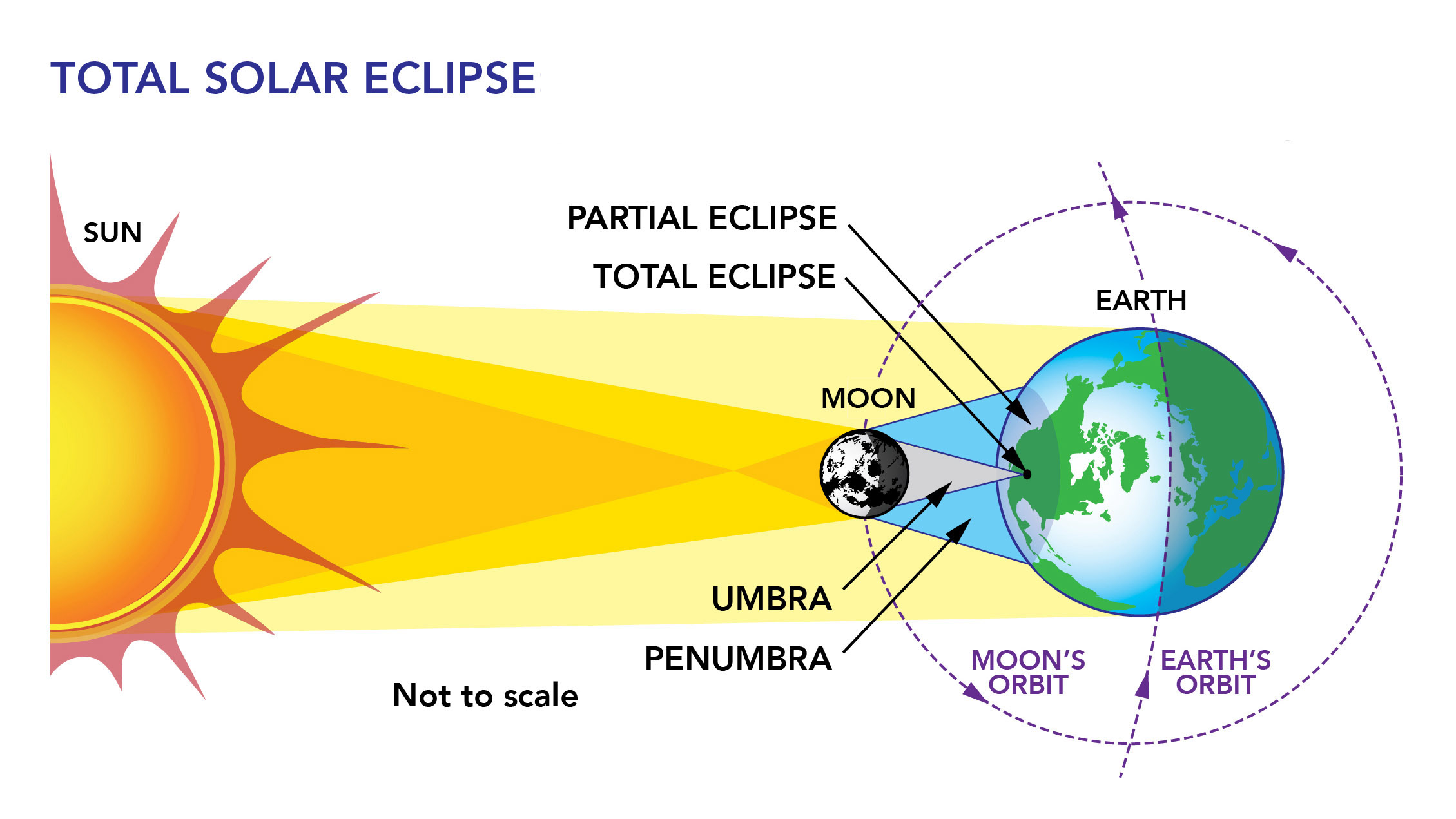
Figure 2. A solar eclipse occurs when the Moon passes between the Sun and Earth, casting a shadow over parts of Earth and blocking the face of the Sun. (Credit: https://mynasadata.larc.nasa.gov/basic-page/solar-eclipses)[click to enlarge]
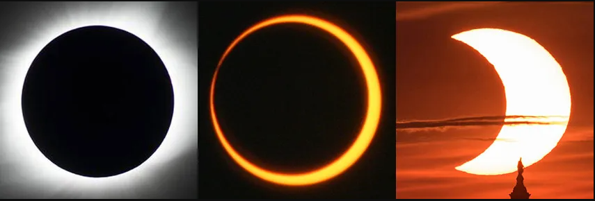
Figure 3. NASA Photographs of a (a) total, (b) annular, and (c) partial solar eclipse (Credit: Total eclipse (left): NASA/MSFC/Joseph Matus; annular eclipse (center): NASA/Bill Dunford; partial eclipse (right): NASA/Bill Ingalls)[click to enlarge]
Satellite and Surface Weather Conditions
April 8, 2024 offered a rare opportunity to observe the atmospheric response to a total solar eclipse across the North Country. Eclipse day dawned sunny, but some high cirrus clouds streamed in across northern New York and western Vermont by early afternoon ahead of a frontal system over western New York. Fortunately, these clouds were generally thin and didn't substantially detract from the viewing experience, with the sun's corona - the outermost part of the Sun's atmosphere - visible during totality in most areas.
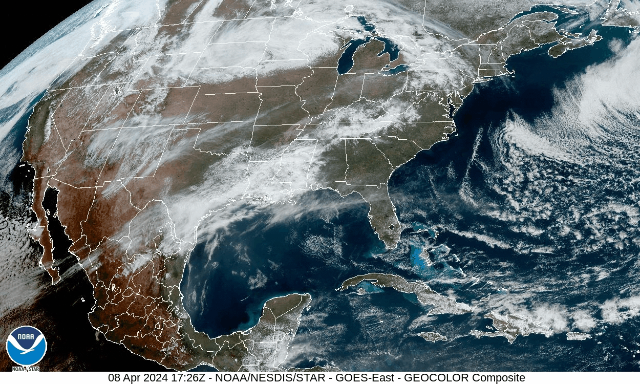
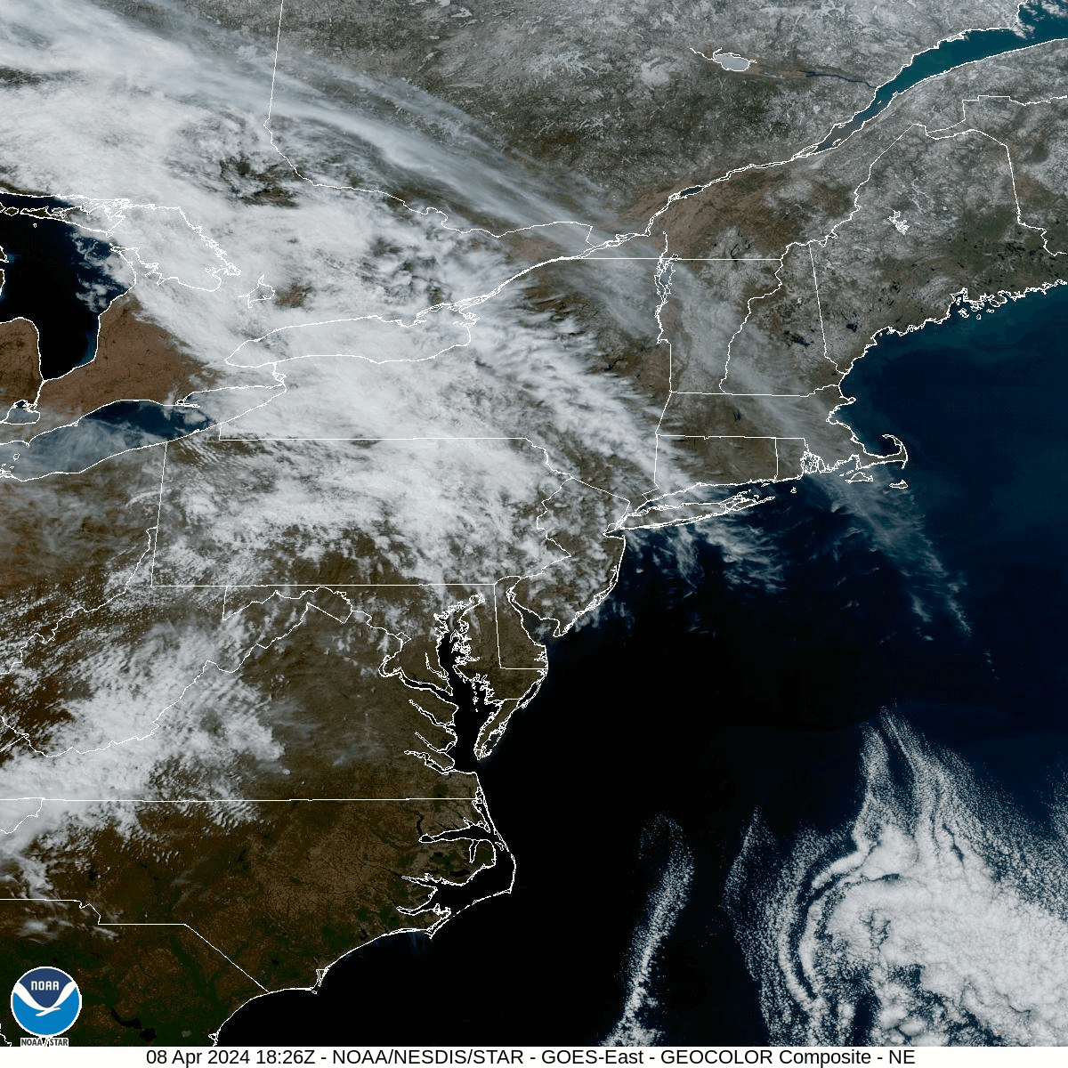
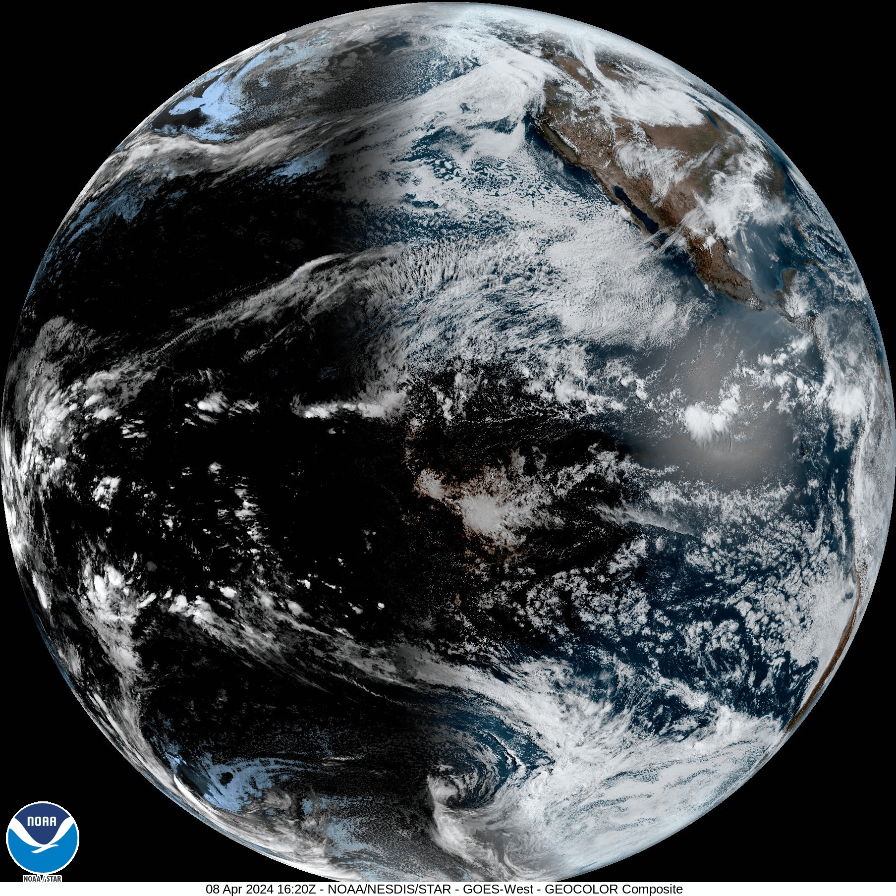
NOAA Geostationary satellites captured the moon's shadow as it crossed North America and adjacent oceanic regions from southwest to northeast (Fig. 4). Here are image loops of the eclipse from the perspective of GOES-East and GOES-West during the afternoon hours on 8 April 2024 in 5-minute increments:
GOES-EAST CONUS Geocolor Composite (1726Z - 2021Z)
GOES-EAST Northeast US Geocolor Composite (1726Z - 2021Z)
GOES-WEST Full Disk Geocolor Composite (1620Z - 1810Z)
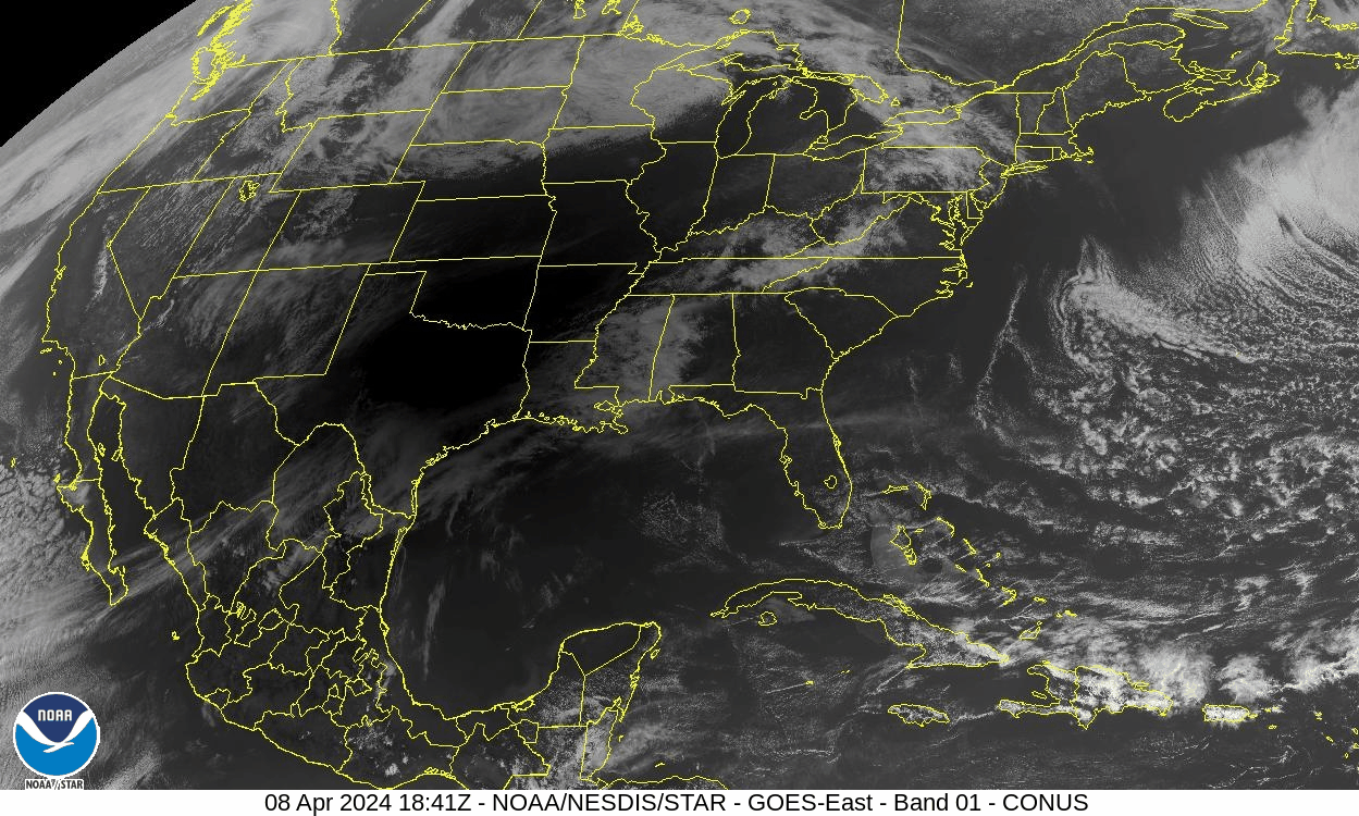
Figure 4. The GOES-16 visible satellite view (Band 01) across the Continental United States and adjacent areas at 2:41 pm EDT on 8 April 2024. At this time, portions of North Texas are in totality (dark region on satellite) and the partial eclipse is underway across northern New York and Vermont [see links for image animations].[click to enlarge]
In terms of surface weather conditions, there were three primary effects noted leading into the period of totality and just beyond: (1) a decrease in temperature, (2) an increase in dewpoint, and (3) a decrease in wind speed. These effects are quite similar to what is observed at the end of quiescent weather days with the onset of radiative cooling as solar insolation is lost at sunset. The Highgate, Vermont airport (KFSO) is located close to the centerline of the path of totality, and 20-minute data from the site is used for illustrative purposes (Figs. 5 and 6). At Highgate, the temperature reached 64°F at 2:35pm EDT. Thereafter, a steady temperature drop was noted as insolation was steadily lost as an increasing amount of the moon obscured the sun. The temperature drop continued through the period of totality and just beyond, falling to 57°F at 3:55pm EDT. This represented a total temperature drop of 7 degrees Fahrenheit. Even though the sun was increasingly bright after totality (~3:30 pm EDT), it took some time for the downward temperature trend to reverse.
The low-level air mass across Vermont was quite dry on the day of the eclipse. We refer to the layer of air adjacent to the Earth's surface as the planetary boundary layer, or simply the boundary layer. The boundary layer is the layer of air near the ground in which the frictional effects of the Earth's surface are felt, and is often characterized by eddies and turbulent mixing. The boundary layer depth varies diurnally from just tens of meters at night, up to several kilometers during daylight periods on warm, sunny days.
With daytime heating and a deepening boundary layer, the dewpoint temperature had been slowly falling throughout the late morning and afternoon hours, reaching a minimum of 26°F at 3:15pm EDT (Fig. 5). Thereafter, a dewpoint rise to 29°F was noted at 3:55pm, which is common during periods of radiative cooling as boundary layer winds and mixing are reduced. In conjunction with the falling temperatures, this represented a period of rising relative humidity near and just after the time of totality. After 3:55 pm EDT, dewpoints resumed their fall as boundary layer winds and mixing again increased, with the Highgate dewpoint reaching a value of 23°F at 4:55pm EDT.
With high pressure in control across Northern New England on eclipse day, surface winds were relatively light areawide. At Highgate, wind speeds remained at 7 mph or below throughout the daylight period (Fig. 6). Even so, the wind speeds dropped to calm in the 3:35 pm and 3:55 pm EDT observations as boundary layer conditions briefly become cooler and more stable, reducing turbulent mixing from aloft.
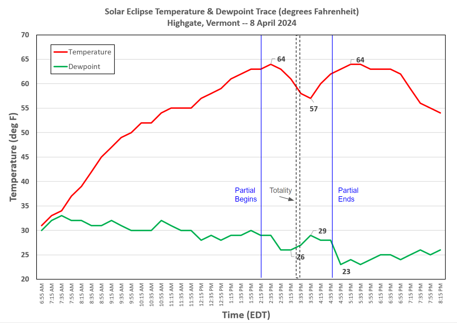
Figure 5. A time series of temperature (red solid line) and dewpoint (green solid line) (in °F) for Highgate, VT (KFSO) from 6:55 am through 8:15 pm EDT on 8 April 2024. The blue vertical lines denote the start and end times of the partial solar eclipse across Northwest Vermont. The dashed black lines indicate when the region was in totality around 3:30 pm EDT.[click to enlarge]
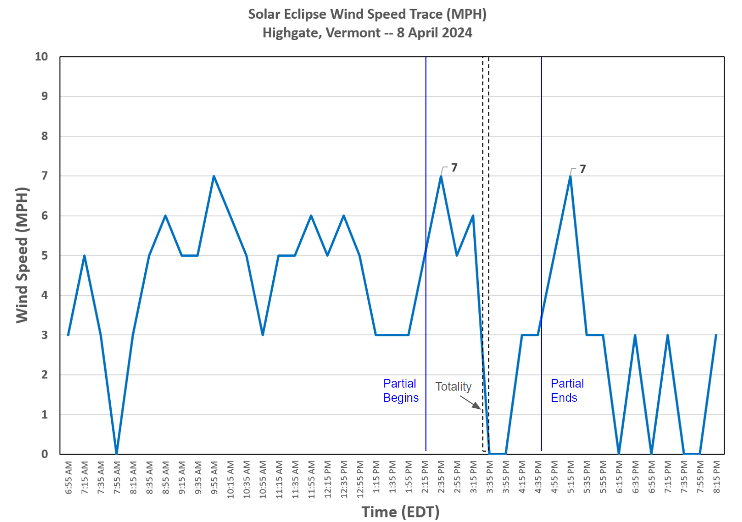
Figure 6. As in Figure 5, except for surface wind speed (blue solid line) in miles per hour.[click to enlarge]
Due to the moon's blockage of the sun's incoming solar radiation, temperatures dropped regionwide between roughly 2:30 pm and 3:45 pm EDT. However, the exact temperature dropped associated with the eclipse varied considerably across the area. This is likely due to local land surface, orographic, and wind effects at individual locations. The presence of high clouds of varying coverage and thickness may also have modulated the degree of radiative cooling to some extent, contributing to some of the differences. The variation in the temperature change is summarized for select New York State Mesonet stations in northern New York, showing that the Saranac location dropped over 10 degrees Fahrenheit while the Potsdam location observed a temperature drop of just over 4 degrees (Table 1).
| New York State Mesonet Station | Temperature Drop |
| Saranac | 10.3 ° |
| North Hudson | 9.5 ° |
| Essex | 8.7 ° |
| Whiteface Mountain Base | 6.4 ° |
| Gabriels | 5.3 ° |
| Potsdam | 4.3 ° |
Boundary Layer Decay During the Eclipse
In Section 2, the temperature drop and near calm winds during the eclipse were discussed as part of a stabilizing boundary layer associated with the loss of incoming solar radiation. Part of this stabilization coincided with a reduction in boundary layer height (PBLH). The New York State Mesonet site at Chazy was near the path of totality centerline, and is one of several stations in the network to have Doppler Light Detection and Randling (LiDAR) remote sensing instrumentation. The LiDAR can be thought of as a vertically pointing radar that records the signal backscattered from very small suspended objects in the air, including aerosols in clear air situations such as April 8th, 2024. The Carrier-to-Noise Ratio (CNR) is a measure of the backscattered signal strength in decibels (Fig. 7), and can provide us an estimate of PBLH in the lowest few kilometers of the atmosphere (Shrestha 2022).
During periods of surface heating and strong turbulent mixing near the ground, there is typically a nearly uniform distribution of aerosol particles within the boundary layer, with a strong negative gradient in such particles at the interface between the boundary layer and the free atmosphere above. This negative gradient shows up as higher returns in CNR, and can be used to infer the top of the boundary layer or PBLH. As such, the development of the daytime boundary layer can be seen in the CNR plot in Figure 7 around 11am, with CNR values rising above -20 dB to heights near 2 km around 2 pm EDT. After 2 pm EDT, the impact of the eclipse becomes increasingly apparent on the boundary layer with the PBLH and maximum CNR values steadily falling closer to the ground between 2 pm and 4 pm EDT. There is some modest increase in PBLH after 4 pm EDT during the post-eclipse daylight period, before fading out as a residual layer with very low dB values as the near-surface layer becomes stable around sunset and turbulent mixing near the Earth's surface decreases.
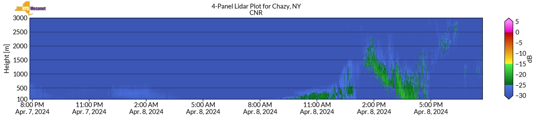
Figure 7. The New York State Mesonet LiDAR Carrier-to-Noise Ratio (CNR) in the 100m to 3000m layer closest to the ground from 8 pm EDT on April 7th through 8 pm EDT on April 8th, 2024. Color-filled areas represent backscattered energy in decibels (dB) per the scale shown.[click to enlarge]
Summary
The rare, total solar eclipse during the afternoon of 8 April 2024 was awe inspiring for the residents and visitors to Vermont and northern New York. While cloud climatology suggested a 70-80% chance of cloudy conditions, the eclipse fortunately occurred during a period of mostly sunny conditions through a thin veil of high cirrus associated with a narrow ridge of surface high pressure. The meteorological impacts of the eclipse stemming from the loss of incoming solar radiation took place over a period of roughly two hours. Though local variability was noted, the primary meteorological impacts included a brief temperature drop of 4-10 degrees Fahrenheit, an increase in surface dewpoints and relative humidity, a decrease in surface wind speed near totality, and a decay of the planetary boundary layer with a reduction in boundary layer height.
Acknowledgments and References
Some meteorological data in this writeup is courtesy of the New York State Mesonet. Please see their website at: https://nysmesonet.org/ and their eclipse dashboard at: https://operations.nysmesonet.org/public/eclipse-2024/.
Shrestha, B., J. A. Brotzge, and J. Wang, 2022: Evaluation of the New York State Mesonet Profiler Network Data. Atmospheric Measurement Techniques, 15, 6011-6033.
Other Links

